Connectivity Maps for Subdivision Surfaces.
Abstract
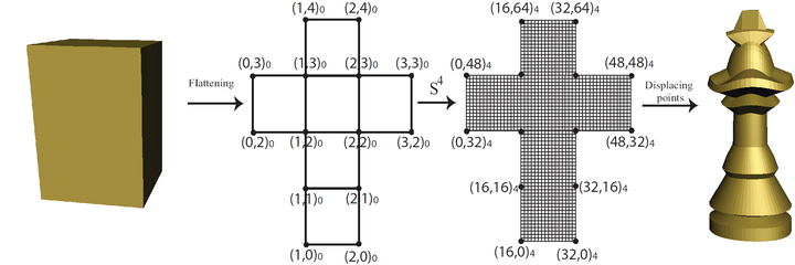
In this paper, we introduce a hierarchical indexing for adjacency queries specially for applying subdivision schemes on somesimple spherical and toroidal polyhedrons as the base model for the content creation process. The indexing method is created from integer coordinates of regular 2D domains (connectivity maps) resulting from unfolding polyhedrons. All connectivities are found using algebraic relationships of the connectivity map’s indices; therefore, no additional data structure is required and operations are extremely fast and efficient. Although connectivity relationships of the polyhedrons are as simple as the first resolution, the models created by our proposed method is not restricted to the subdivided polyhedrons. Using our connectivity based method, complex objects can be created by adding sharp features and holes and applying deformation and remeshing techniques. We demonstrate capacities and the efficiency of the method with several example results and compare its speed with that of the half-edge data structure.
Ali Mahdavi-Amiri
Alumni Postdoc and Research Associate
April 2015 - December 2016
Ali is a former Postdoctoral Scholar interested in geometric modelling, geospatial visualization, Digital Earth representations, and spatial data structures.