The Evolution of Data-Driven Management Zone Delineation: A Systematic Review (2026)
By partitioning agricultural fields into units with similar yield-limiting factors, Management Zone (MZ) delineation provides the …

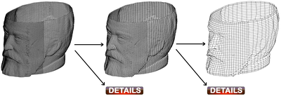
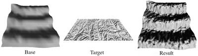
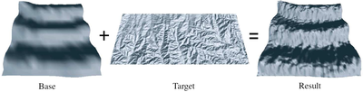
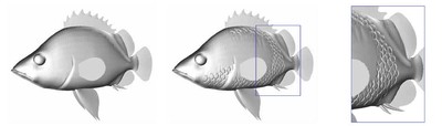
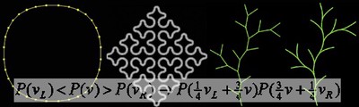
Controllable Intrinsic Surface Pattern Generation Using Slime Mold Simulations (2026)
Surface-based pattern simulations have proven valuable for texture design and scientific visualization, but existing methods face …

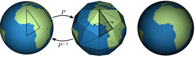
Spherical Geodesic Bounds and a k-Circle Coverage Formulation (2026)
In this article, we introduce analogues of classic Euclidean bounds, including spherical caps, geodesic axis-aligned bounding boxes …

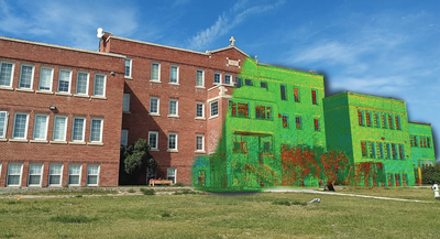
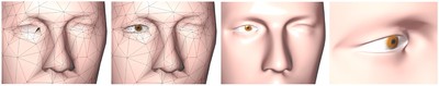
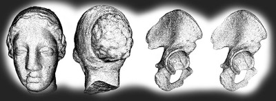
Rethinking the commemoration of Indian Residential Schoolsthrough digital heritage (2026)
This paper examines the use of digital twins – highly accuratevirtual models of physical structures created through terrestrialLiDAR …
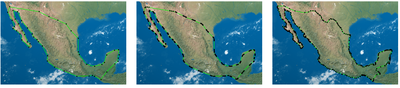
Assessing Surface Water Dynamics of Wetlands in Reclaimed Mining Areas in the Athabasca Oil Sands Region, Alberta, Canada, with Time-Varying Sentinel-1 SAR and Sentinel-2 Multi-Spectral Imagery (2025)
Wetlands provide critical ecological and socio-economic benefits, covering approximately 45% of the Athabasca Oil Sands Region in …

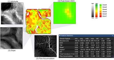
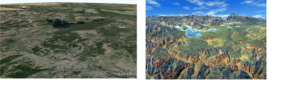
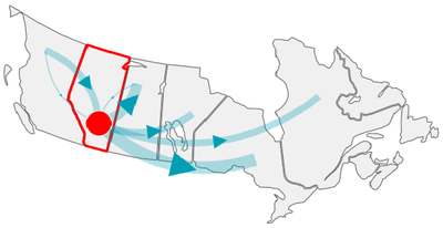
Terrain Matters: A Focus+Context Visualization Approach for Landform-Based Remote Sensing Analysis of Agricultural Performance (2025)
Understanding spatial variability is central to precision agriculture, yet terrain features are often overlooked in remote sensing …
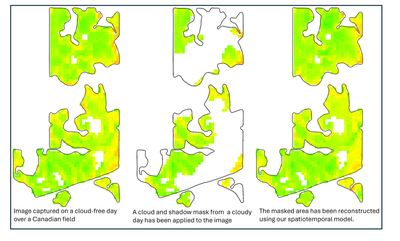
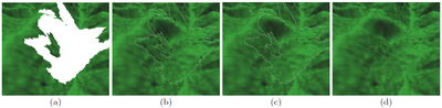
Distance Transform-Based Spatiotemporal Model for Approximating Missing NDVI from Satellite Data (2025)
One widely used method for analyzing vegetation growth from satellite imagery is the Normalized Difference Vegetation Index (NDVI), a …
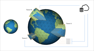
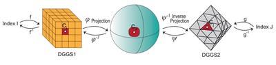
Real-Time Multiresolution Management of Spatiotemporal Earth Observation Data Using DGGS (2025)
The effective management of spatiotemporal Earth observation data is a significant challenge due to their growing size and scale, …
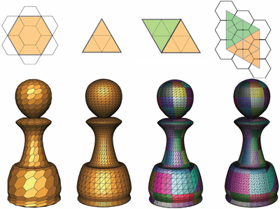
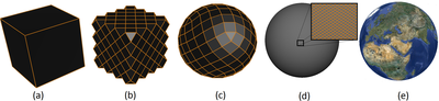
Constructing Efficient Mesh-Based Global Grid Systems with Reduced Distortions (2024)
Recent advancements in geospatial technologies have significantly expanded the volume and diversity of geospatial data, unlocking new …
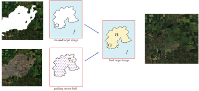
Variational-Based Spatial–Temporal Approximation of Images in Remote Sensing (2024)
This paper presents a new approach to enhancing cloud-contaminated satellite images using a novel variational model for approximating …
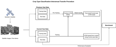
Evaluation of Data Sufficiency for Interannual Knowledge Transfer of Crop Type Classification Models (2024)
We present a study on the effectiveness of using varying data sizes to transfer crop type classification models from one year to the …
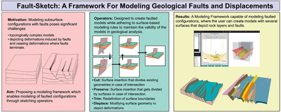
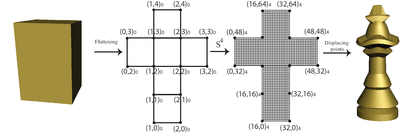
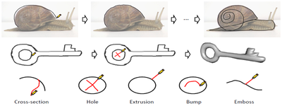
Fault-sketch: A framework for modeling geological faults and displacements (2024)
Geological faults, which result from rock fracturing and displacement in the subsurface, play an important role in shaping the Earth’s …
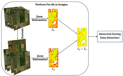
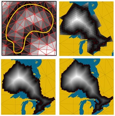
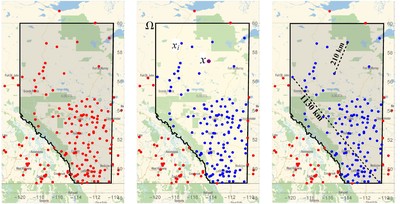
A New Dissimilarity Metric for Anomaly Detection in Management Zones Delineation Constructed from Time-Varying Satellite Images (2024)
A field’s historical performance data are used for management zone delineation in precision agriculture, but including abnormal data …
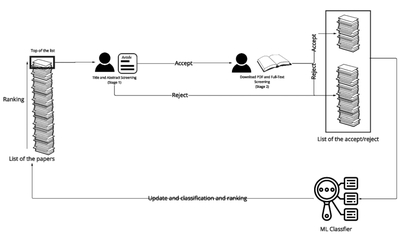
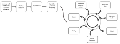
Systematic review using a spiral approach with machine learning (2024)
With the accelerating growth of the academic corpus, doubling every 9 years, machine learning is a promising avenue to make systematic …
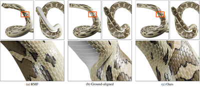
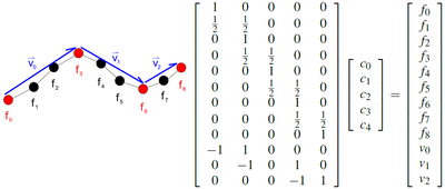
Balancing Rotation Minimizing Frames with Additional Objectives (2023)
When moving along 3D curves, one may require local coordinate frames for visited points, such as for animating virtual cameras, …
Automatic Soil Sampling Site Selection in Management Zones Using a Multi-Objective Optimization Algorithm (2023)
Precision agriculture hinges on accurate soil condition data obtained through soil testing across the field, which is a foundational …

First Insights Into INTUIT: An INteractive Tactile Physicalization for User Interpretation of RADAR Technology (2023)
The changing climate and increasingly unpredictable sea ice conditions have created life-threatening risks for Inuit, the residents of …
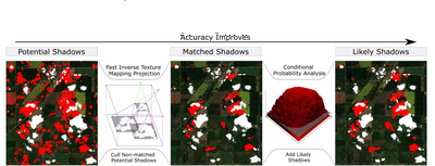
Cloud Shadow Detection via Ray Casting with Probability Analysis Refinement Using Sentinel-2 Satellite Data (2023)
Analysis of aerial images provided by satellites enables continuous monitoring and is a central component of many applications, …
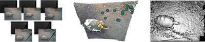
A Multi-Resolution Approach to Point Cloud Registration without Control Points (2023)
Terrestrial photographic imagery combined with structure-from-motion (SfM) provides a relatively easy-to-implement method for …
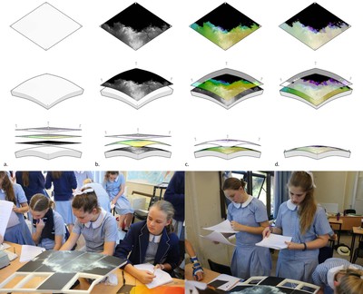
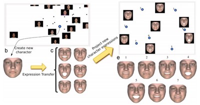
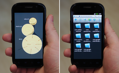
Mobile Augmented Reality for Adding Detailed Multimedia Content to Historical Physicalizations (2022)
Combining augmented reality (AR) and physicalization offers both opportunities and challenges when representing detailed historical …
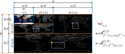
Efficient Calculation of Distance Transform on Discrete Global Grid Systems (2022)
Geospatial data analysis often requires the computing of a distance transform for a given vector feature…
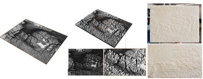
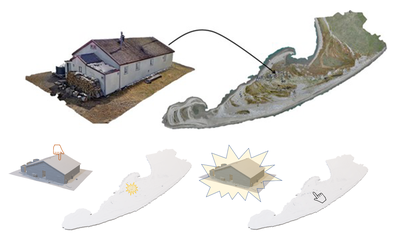
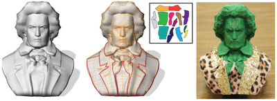
Multi-scale physicalization of polar heritage at risk in the western canadian arctic (2022)
The digital preservation of heritage resources has emerged as an essential method for communicating the significance of artifacts, …
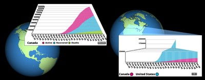
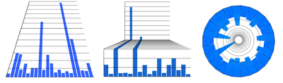
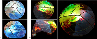
Perspective Charts in a Multi-Foci Globe-Based Visualization of COVID-19 Data (2022)
The use of perspective projection in data visualization has been shown to potentially aid with the perception of small values in …
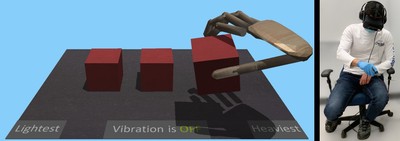
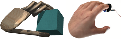
Mass simulation in VR using vibrotactile feedback and a co-located physically-based virtual hand (2022)
Virtual reality allows for highly immersive simulated experiences and interaction with virtual objects. However, virtual objects do not …
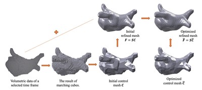
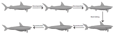
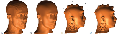
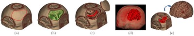
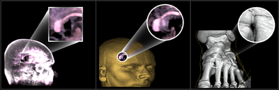
4D Surface Mesh Reconstruction from Segmented Cardiac Images using Subdivision Surfaces (2021)
With the advances in cardiovascular imaging technologies in recent years, 4D (3D+time) patient-specific modeling of the heart has …
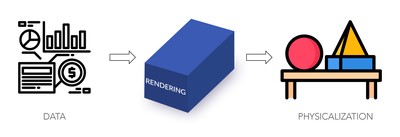
Data to Physicalization: A Survey of the Physical Rendering Process (2021)
Physical representations of data offer physical and spatial ways of looking at, navigating, and interacting with data. While digital …
Perspective Charts (2021)
We introduce three novel data visualizations, called perspective charts, based on the concept of size constancy in linear perspective …
Simulating Mass in Virtual Reality using Physically-Based Hand-Object Interactions with Vibration Feedback (2021)
Providing the sense of mass for virtual objects using un-grounded haptic interfaces has proven to be a complicated task in virtual …
Weather daily data approximation using point adaptive ellipsoidal neighborhood in scattered data interpolation methods (2021)
Many papers have applied the meshless method to approximate a function by using a set of scattered data. To use a meshless method, we …
Geospatial Physicalization in Geography Education (2020)
A novel method to create a physicalization of Digital Earth resulted a new type of analogue and tactile geographic information system …
Interactive data styling and multifocal visualization for a multigrid web-based Digital Earth (2020)
Globe-based Digital Earth (DE) is a promising system that uses 3D models of the Earth for integration, organization, processing, and …

Disdyakis Triacontahedron DGGS (2020)
The amount of information collected about the Earth has become extremely large. With this information comes the demand for integration, …
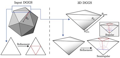
General Method for Extending Discrete Global Grid Systems to Three Dimensions (2020)
Geospatial sensors are generating increasing amounts of three-dimensional (3D) data. While Discrete Global Grid Systems (DGGS) are a …
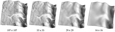
RIAS: Repeated Invertible Averaging for Surface Multiresolution of Arbitrary Degree (2020)
In this paper, we introduce two local surface averaging operators with local inverses and use them to devise a method for surface …
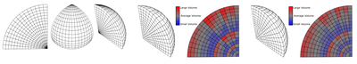
Toward volume preserving spheroid degenerated-octree grid (2020)
Conventional Discrete Global Grid Systems are well suited for storing and indexing data on the Earth's surface, but not for data above …
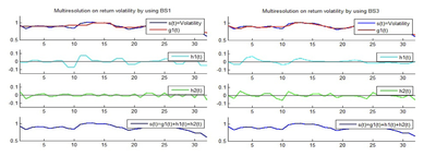
Improving DWT-RNN model via B-spline wavelet multiresolution to forecast a high-frequency time series (2019)
This paper presents a recurrent neural network (RNN) which is improved by using an efficient discrete wavelet transform (DWT) for …
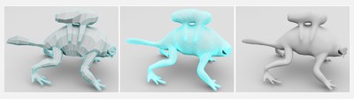
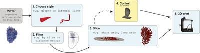
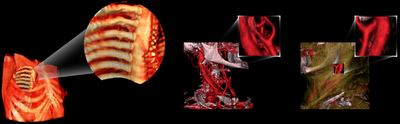
Physicalizing cardiac blood flow data via 3D printing (2019)
Blood flow data from cardiac 4D Flow MRI (magnetic resonance imaging) holds much potential for research and diagnosis of flow-related …
Digital Earth Platforms (2019)
In this chapter, we provide a thorough discussion on Digital Earth with particular focus on Discrete Global Grid Systems (DGGS), which …

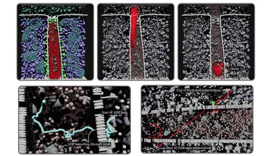
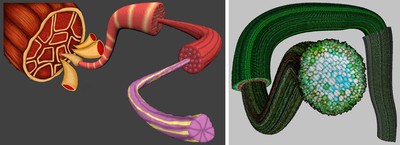
LifeBrush: Painting, simulating, and visualizing dense biomolecular environments (2019)
LifeBrush is a Cyberworld for painting dynamic molecular illustrations in virtual reality (VR) that then come to life as interactive …
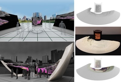
Data-spatialized Pavilion: Introducing a Data-driven Design Method based on Principles of Catoptric Anamorphosis (2019)
Data spatialization is a design technique through which data is used to create architectural spaces. It does not necessarily preserve …
Multiscale NURBS curves on the sphere and ellipsoid (2019)
In this paper, we introduce a framework that allows NURBS subdivision curves to be defined on the sphere and ellipsoid in a multiscale …
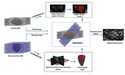
Sketch-based Registration of 3D Cine MRI to 4D flow MRI (2019)
Cardiac 4D Flow magnetic resonance imaging (4D Flow MRI) is a recent powerful technology that uniquely enables in-vivo acquisition of …
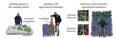
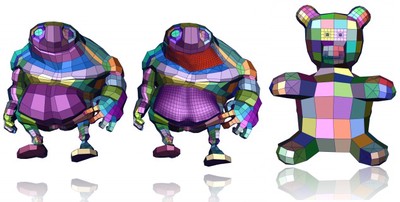
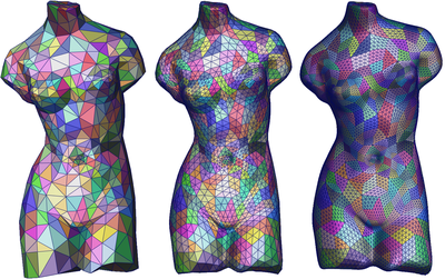
Interactive example-palettes for discrete element texture synthesis (2019)
Textures composed of individual discrete elements are found in everything from human-made glass-tilings to forests and tropical coral. …
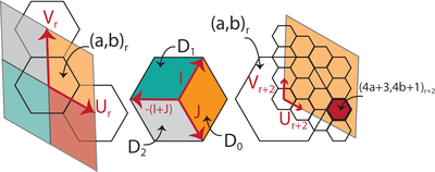
Digital earth system featuring integer-based connectivity mapping of aperture-3 hexagonal cells (2019)
A digital Earth system based upon a hexagonal subdivision of a polyhedron representation of the Earth utilizes a computer-implemented …
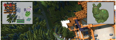
LifeBrush: Painting interactive agent-based simulations (2018)
Building and interacting with 3D agent-based simulations that contain a large number of agents is a significant challenge. What if we …
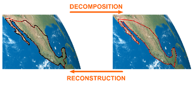
Offsetting spherical curves in vector and raster form (2018)
In this paper, we present techniques for offsetting spherical curves represented in vector or raster form. Such techniques allow us to …

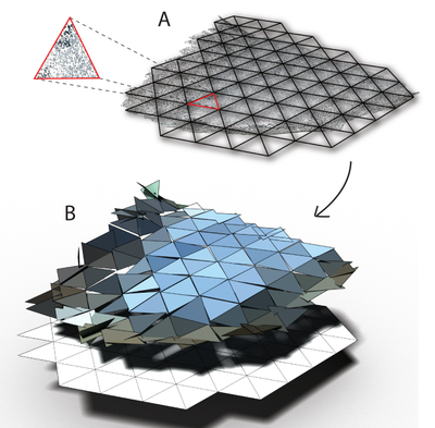
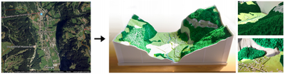
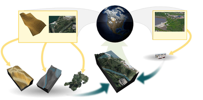
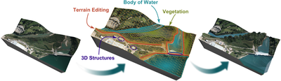
Landscaper: A Modeling System for 3D Printing Scale Models of Landscapes (2018)
Landscape models of geospatial regions provide an intuitive mechanism for exploring complex geospatial information. However, the …
Geospatial Data Organization Methods with Emphasis on Aperture 3 Hexagonal Discrete Global Grid Systems (2018)
Digital Earth frameworks deal with data sets of different types collected from various sources. In order to effectively store, …
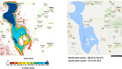
Single image summary of time-varying Earth-features (2018)
The Earth’s surface is live and dynamic due to natural and manmade events. Tracking and visualizing Earth-features (eg water, snow, and …
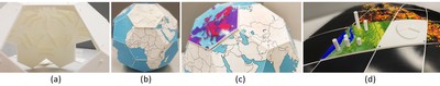
Area Preserving Dynamic Geospatial Visualization on Physical Globe. (2018)
We present a methodology for creating dynamic visualization of geospatial data on physical globe. To achieve this goal, we use a …
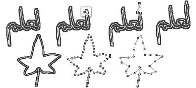
Illustrative multilevel focus+ context visualization along snaking paths (2017)
Artistic anatomical illustrations often focus on cross sections of long, layered, cylindrical structures. Such illustrations emphasize …
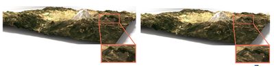
Real-time panorama maps (2017)
Panorama maps are stylized paintings of terrain often seen at tourist destinations. They are difficult to create since they are both …
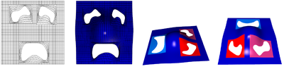
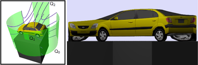
Parameter Aligned Trimmed Surfaces. (2017)
We present a new representation for trimmed parametric surfaces. Given a set of trimming curves in the parametric domain of a surface, …
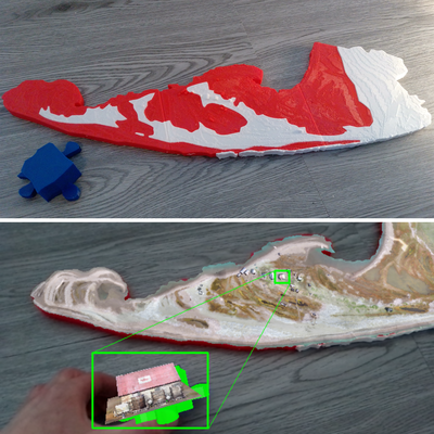
Physical visualization of geospatial datasets (2017)
Geospatial datasets are too complex to easily visualize and understand on a computer screen. Combining digital fabrication with a …
Subdivision and multiresolution for pups (2017)
Partition of Unity Parametrics (PUPs) is a generalization of NURBS that permits the use of arbitrary basis functions to model …
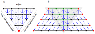
Diagrammatic approach for constructing multiresolution of primal subdivisions (2017)
It is possible to define multiresolution by reversing the process of subdivision. One approach to reverse a subdivision scheme …
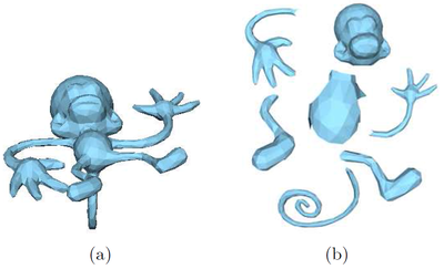
Automated 3D Reconstruction of Moving Rigid Specimen from RGB-D Video Input (2016)
To assist morphometric and behavioural analysis of live animals, we present an automatic process for generating a 3D volumetric …
Interactive 3D content modeling for digital earth (2016)
Digital Earth is a global reference model for integrating, processing and visualizing geospatial datasets. In this reference model, …
Hierarchical grid conversion (2016)
Hierarchical grids appear in various applications in computer graphics such as subdivision and multiresolution surfaces, and terrain …
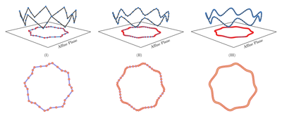
Multiresolution on spherical curves (2016)
In this paper, we present an approximating multiresolution framework of arbitrary degree for curves on the surface of a sphere. …
A Subdivision Framework for Partition of Unity Parametrics. (2016)
Partition of Unity Parametrics (PUPs) are a generalization of NURBS that allow us to use arbitrary basis functions for modeling …
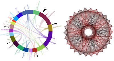
Daisy visualization for graphs (2016)
Since graphs are ubiquitous representations of data that are used in many applications, creating graph layouts is an important problem. …
Interactive multilevel focus+ context visualization framework (2016)
In this article, we present the construction of an interactive multilevel focus+context visualization framework for the navigation and …
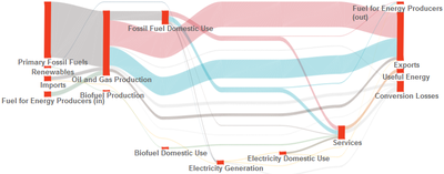
EnergyViz: an interactive system for visualization of energy systems (2016)
Energy systems are under pressure to transform to address concerns about climate change. The modeling and visualization of energy …
Artistic Inspired Data Visualization Design Process (2016)
In this paper we describe our design process for creating artistically inspired data visualizations. We consider graphs as an example …
A survey of digital earth (2015)
The creation of a digital representation of the Earth and its associated data is a complex and difficult task. The incredible size of …
3d maquetter: Sketch-based 3d content modeling for digital earth (2015)
We present a sketch-based system for the creation and editing 3D content such as Digital Elevation Models, vegetation and bodies of …
Hexagonal connectivity maps for Digital Earth (2015)
Geospatial data are gathered through a variety of different methods. The integration and handling of such datasets within a Digital …

Cover-it: an interactive system for covering 3D prints (2015)
The ubiquity of 3D printers has made it possible to print various types of objects, from toys to mechanical objects. However, most …
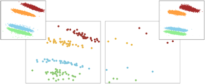
Facing the high-dimensions: Inverse projection with radial basis functions (2015)
Multidimensional projection has become a standard tool for visual analysis of multidimensional data sets, as the 2D representation of …
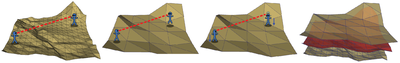
Optimizing line-of-sight using simplified regular terrains (2015)
In this work, we explore a set of techniques for speeding up line-of-sight queries whilst attempting to maintain accuracy. …
Balanced multiresolution for symmetric/antisymmetric filters (2015)
Given a set of symmetric/antisymmetric filter vectors containing only regular multiresolution filters, the method we present in this …
Rapid reservoir modeling: Prototyping of reservoir models, well trajectories and development options using an intuitive, sketch-based interface (2015)
Constructing or refining complex reservoir models at the appraisal, development, or production stage is a challenging and …
Categorization and Conversions for Indexing Methods of Discrete Global Grid Systems (2015)
Digital Earth frameworks provide a tool to receive, send and interact with large location-based data sets, organized usually according …
Node-ring graph visualization clears edge congestion (2014)
The most common graph visualization techniques still use nodelink layouts; where the nodes represent the entities and the links …
Multilevel focus+ context visualization using balanced multiresolution (2014)
In this paper, we present the construction of a multilevel focus context visualization framework for the navigation and exploration of …
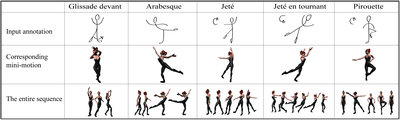
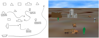
Sketch-Based Dance Choreography (2014)
Sketching and doodling are two techniques commonly used by choreographers to design a dance sequence. These sketches usually represent …
Interactive Visualization of Energy System (2014)
Energy systems are under pressure to transform in order to address concerns about climate change. The modeling and visualization of …
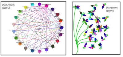
Spirograph inspired visualization of ecological networks (2014)
Ecological networks are directed weighted graphs for representing direct and indirect relationships between species in ecosystems. …
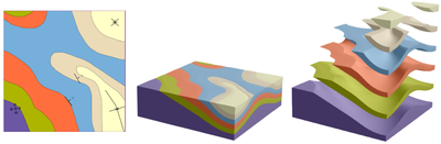
3D geological modeling using sketches and annotations from geologic maps (2014)
Constructing 3D geological models is a fundamental task in oil/gas exploration and production. A critical stage in the existing 3D …
CINPACT-splines: A Class of Curves with Compact Support (2014)
Recently, Runions and Samavati [7] proposed Partion of Unity Parametrics (PUPs), a generalization of NURBS which replaces B-spline …
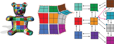
Adaptive atlas of connectivity maps (2014)
The Atlas of Connectivity Maps (ACM) is a data structure designed for semiregular meshes. These meshes can be divided into regular, …
Atlas of connectivity maps (2014)
Semiregular models are now ubiquitous in computer graphics. These models are constructed by refining a model with an arbitrary initial …
Multidimensional projection with radial basis function and control points selection (2014)
Multidimensional projection techniques provide an appealing approach for multivariate data analysis, for their ability to translate …
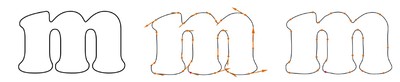
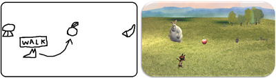
A pen and paper interface for animation creation (2014)
We present a Sketch Based Interface that allows non-expert users to create an animation with sound from a drawing on paper. Current …
PaisleyTrees: A Size-Invariant Tree Visualization. (2014)
Squeezing large tree structures into suitable visualizations has been a perennial problem. In response to this challenge, we present …
One-to-two digital earth (2013)
The digital Earth framework is a multiresolution 3D model used to visualize location-based data. In this paper, we introduce a new …
Local fairing with local inverse (2013)
Local fairing techniques are extensively used in the geometry processing of curves and surfaces. They also play an important role in …
ACM: Atlas of connectivity maps for semiregular models (2013)
Semiregular models are an important subset of models in computer graphics. They are typically obtained by applying repetitive regular …
Sketch-Based Interface for animation for non-experts (2012)
We present a Sketch-Based Interface that allows non-expert users to create an animation from just pencil and paper. The interface works …
Connectivity Maps for Subdivision Surfaces. (2012)
In this paper, we introduce a hierarchical indexing for adjacency queries specially for applying subdivision schemes on somesimple …
Reverse Subdivision for Optimizing Visibility Tests. (2012)
Certain applications require knowledge of whether two entities are visible to each other over a terrain, determined using a …
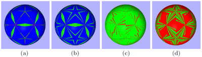
Designing Persian Floral Patterns using Circle Packing. (2012)
In this paper, we present a novel approach toward generating floral patterns. We extract the essence of a pattern aside from its …

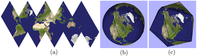
Analysis of inverse Snyder optimizations (2012)
Modern area preserving projections employed by cartographers and geographers have closed forms when transitioning between the sphere …
Naturasketch: Modeling from images and natural sketches (2011)
Sketching on paper is a quick and easy way to communicate ideas. However, many sketch-based systems require people to draw in contrived …
Optimization of inverse Snyder polyhedral projection (2011)
Modern techniques in area preserving projections used by cartographers and other glossarial researchers have closed forms when …
Smooth reverse loop and Catmull–Clark subdivision (2011)
In this paper we present a new multiresolution technique for general topology surfaces based on reversing subdivision with energy …
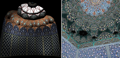
Interactive modeling of muqarnas (2011)
Muqarnas is a mesmerizing 3D feature of Islamic architecture that exhibit intricate geometry. Such designs are composed of several …
Partition of unity parametrics: a framework for meta-modeling (2011)
We propose Partition of Unity Parametrics (PUPs), a natural extension of NURBS that maintains affine invariance. PUPs replace the …
Multiresolutions numerically from subdivisions (2011)
In previous work we introduced a construction to produce multiresolutions from given subdivisions. A portion of that construction …

Super resolution contextual close-up visualization of volumetric data (2011)
The present invention relates to a method and system for processing a volumetric dataset for providing close-up visualization of a …
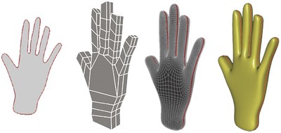
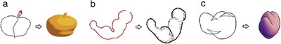
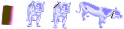
Sketch-based modeling and assembling with few strokes (2011)
In this chapter we present a sketch-based modeling system inspired by artistic illustration techniques. In traditional illustration, 3D …
Sketch-based interfaces and modeling (2010)
The field of sketch-based interfaces and modeling (SBIM) is concerned with developing methods and techniques to enable users to …

L-systems in geometric modeling (2010)
We show that parametric context-sensitive L-systems with affine geometry interpretation provide a succinct description of some of the …
L-systems in geometric modeling (2010)
We show that parametric context-sensitive L-systems with affine geometry interpretation provide a succinct description of some of the …
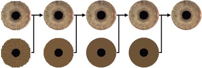
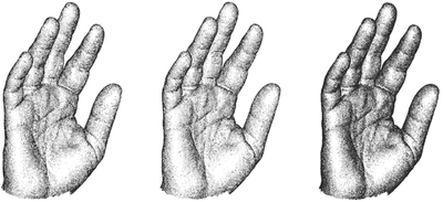
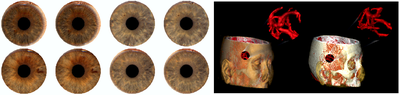
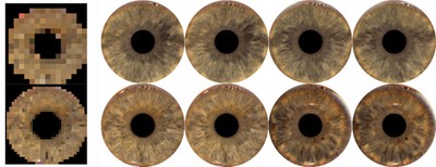
A multiresolution approach to iris synthesis (2010)
Databases of human iris images are created and distributed for the purposes of testing iris identification algorithms. For logistical …
Sketch based volumetric clouds (2010)
Like many natural phenomenon, clouds are often modeled using procedural methods, which may be difficult for an artist to control. In …

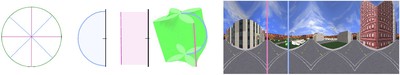
Shape defined panoramas (2010)
Panoramic projections are often defined by the geometric surfaces used to derive the projections’ equations (e.g., spherical and …
Local constraint-based general surface deformation (2010)
This paper develops a framework for locally deforming either a parametric surface or hierarchical subdivision surface to match a set of …
Stroke extraction and classification for mesh inflation (2010)
We provide a method for extracting and classifying stroke segments from a line drawing or sketch with the goal of producing …
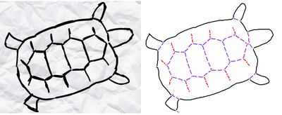
Image-assisted modeling from sketches (2010)
In this paper, we propose a method for creating freeform surfaces from sketch-annotated images. Beginning from an image, the user …
Methods, systems, and computer program products for GPU-based point radiation for interactive volume sculpting and segmentation (2009)
Internal structures, features and properties in volumetric datasets are mostly obscured and hidden. In order to reveal and explore …
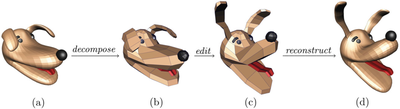
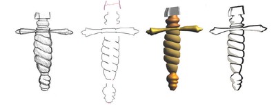
Sketch-based subdivision models (2009)
Designing a control mesh (or a polyhedron) for a subdivision model is a tedious task. It involves many difficult decisions such as how …
Smooth reverse subdivision (2009)
In this paper we present a new multiresolution framework that takes into consideration reducing the coarse points’ energy during …
Real-time multi-band synthesis of ocean water with new iterative up-sampling technique (2009)
Adapting natural phenomena rendering for real-time applications has become a common practice in computer graphics. We propose a …

Sketch-based modeling: A survey (2009)
User interfaces in modeling have traditionally followed the WIMP (Window, Icon, Menu, Pointer) paradigm. Though functional and very …
Art and Nonlinear Projection (2009)
Nonlinear projection is a current area of research in computer graphics. It provides a meeting place between science and art. After …
GPU-based point radiation for interactive volume sculpting and segmentation (2008)
Internal structures, features, and properties in volumetric datasets are mostly obscured and hidden. In order to reveal and explore …

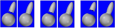
NURBS Fusion (2008)
In this paper, we propose a new NURBS modeling technique, called NURBS fusion and present a complete algorithm for NURBS fusion. …
Animating persian floral patterns (2008)
In this paper we describe Persian floral patterns and explore techniques for animating them. We present several approaches for this …

A Taxonomy of Modeling Techniques using Sketch-Based Interfaces. (2008)
Traditional user interfaces in modeling have followed the WIMP (Window, Icon, Menu, Pointer) paradigm. While functional and powerful, …
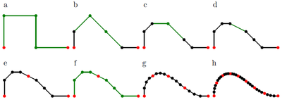
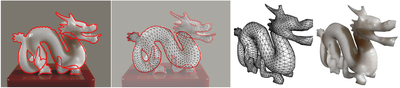
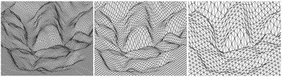
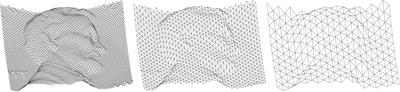
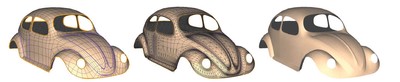
A discrete approach to multiresolution curves and surfaces (2008)
Subdivision surfaces have been widely adopted in modeling in part because they introduce a separation between the surface and the …
Fast stroke matching by angle quantization (2007)
Determining similarity of two point sequences (strokes) is a fundamental task in gestural interfaces. Because the length of each stroke …
3D watermarking robust to accessible attacks (2007)
In this paper we propose a new watermarking approach for 3D polygonal meshes. In the field of multimedia watermarking, mesh …
Capturing and re-using artistic styles with reverse subdivision-based multiresolution methods (2007)
We describe a multiresolution method for rendering curves that is based on exact reproduction of artistic silhouettes and line …
Ribbons: A representation for point clouds (2007)
Point clouds are usually represented either globally, as surfaces, or locally, as sets of points with small neighbourhoods. We propose …
Improving the sketch-based interface (2007)
Sketch-based interfaces are becoming a useful methodology for interaction with a wide range of applications. Drawing is a natural and …
Contextual void patching for digital elevation models (2007)
Digital terrain models can be created by gathering a set of measurements from geometric objects. For various reasons, these models may …
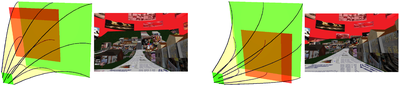
Single camera flexible projection (2007)
We introduce a flexible projection framework that is capable of modeling a wide variety of linear, nonlinear, and hand-tailored …
Purple crayon: from sketches to interactive environment (2007)
controls often required for gameplay hinder the potential for social interaction, especially in domestic settings. Purple Crayon, an …

Multiresolution for curves and surfaces based on constraining wavelets (2007)
We present a novel method for determining local multiresolution filters for a broad range of subdivision schemes. Our approach is based …
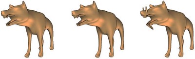
Reverse Loop subdivision for geometry and textures (2007)
Reverse subdivision aims at constructing a coarser representation of an object given by a fine polygon mesh. In this paper, we first …

Polygonal silhouette error correction: a reverse subdivision approach (2007)
A method for automatic removal of artifacts and errors that can appear in silhouettes extracted from polygonal meshes is presented and …
Incremental subdivision for triangle meshes (2007)
We introduce incremental subdivision as a new adaptive subdivision method for triangle meshes. While regular (global) subdivisions …
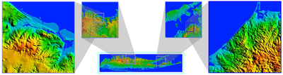
Terrain synthesis by-example (2007)
Synthesizing terrain or adding detail to terrains manually is a long and tedious process. With procedural synthesis methods this …
Terrain synthesis by-example (2007)
Synthesizing terrain or adding detail to terrains manually is a long and tedious process. With procedural synthesis methods this …
Local B-Spline Multiresolution with Example in Iris Synthesis and Volumetric Rendering (2007)
Multiresolution has been extensively used in many areas of computer science, including biometrics. We introduce local multiresolution …
Transformation Strokes. (2006)
In this paper, we present a sketch-based technique for specifying transformations for general models by means of a single stroke, …
Sketch-based Volumetric Seeded Region Growing. (2006)
Interactive volume segmentation is an essential and important step in medical image processing. Conventional interactive methods …

Some observations on local least squares (2006)
In previous work we introduced a construction to produce biorthogonal multiresolutions from given subdivisions. The approach involved …
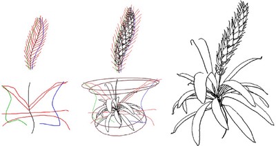
Modeling plant structures using concept sketches (2006)
Creating 3D plant models is often a hard and laborious task. To make it easier and more natural, we propose a sketch-based interface …
Diagrammatic tools for generating biorthogonal multiresolutions (2006)
Elsewhere we have introduced a construction to produce biorthogonal multiresolutions from given subdivisions. This construction was …
Real-time super resolution contextual close-up of clinical volumetric data (2006)
We present an illustrative visualization system for real-time and high quality rendering of clinical volumetric medical data. Our …
Fast intersections for subdivision surfaces (2006)
Subdivision surface intersections can be costly to compute. They require the intersection of high resolution meshes in order to obtain …

Iris synthesis: a reverse subdivision application (2005)
Due to renewed interest in security, iris images have become a popular biometric alternative to fingerprints for human identification. …
Incremental catmull-clark subdivision (2005)
In this paper, a new adaptive method for Catmull-Clark subdivision is introduced. Adaptive subdivision refines specific areas of a …
Sketch-based modeling with few strokes (2005)
We present a novel sketch-based system for the interactive modeling of a variety of free-form 3D objects using just a few strokes. Our …
Sketch-Based Mesh Augmentation. (2005)
This paper describes a sketch-based method for augmenting geometric meshes with variable-scale sharp features. Such mesh editing …
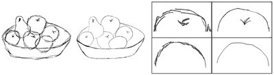
Depicting shape features with directional strokes and spotlighting (2004)
This paper presents a new algorithm and technique for rendering triangular surfaces in pen-and-ink edge-based strokes. Our technique …
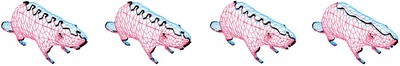
Reverse subdivision multiresolution for polygonal silhouette error correction (2004)
This paper presents a method for automatic removal of artifacts that appear in silhouettes extracted from polygonal meshes due to the …
Incremental adaptive loop subdivision (2004)
In this paper, a new adaptive Loop subdivision algorithm is introduced. Adaptive subdivision refines specific areas of a model …
Silhouette rendering based on stability measurement (2004)
A better silhouette for a mesh can be rendered if we take into account the stability of edges inside and outside the current …
Local filters of b-spline wavelets (2004)
Haar wavelets have been widely used in Biometrics. One advantage of Haar wavelets is the simplicity and the locality of their …
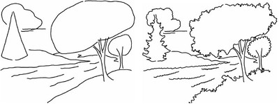
Illustrating terrains using direction of slope and lighting (2004)
Landscape illustrations and cartographic maps depict ter-rain surface in a qualitatively effective way. In this paper, we present a …
Local specification of surface subdivision algorithms (2003)
Many polygon mesh algorithms operate in a local manner, yet are formally specified using global indexing schemes. This obscures the …
Precise ink drawing of 3D models (2003)
Drawings made with precise pen strokes accurately reveal the geometric forms that give subjects their characteristicshape. We present a …
L-system description of subdivision curves (2003)
In recent years, subdivision has emerged as a major geometric modeling technique. Algorithms for generating subdivision curves are …
Progressive curve representation based on reverse subdivision (2003)
A progressive curve representation based on reverse subdivision is introduced. Multiresolution structures for common subdivision rules …
Multiresolution surfaces having arbitrary topologies by a reverse Doo subdivision method (2002)
We have shown how to construct multiresolution structures for reversing subdivision rules using global least squares models (Samavati …

Reversing subdivision rules: Local linear conditions and observations on inner products (2000)
In a previous work (Samavati and Bartels, Comput. Graphics Forum 18 (1998) 97–119) we investigated how to reverse subdivision rules …

A filtered b-spline model of scanned digital images (1999)
We present an approach for modeling and ltering digitally scanned images. The digital contour of an image is segmented to identify the …

Multiresolution curve and surface representation: reversing subdivision rules by least‐squares data fitting (1999)
This work explores how three techniques for defining and representing curves and surfaces can be related efficiently. The techniques …