One-to-two digital earth
Abstract
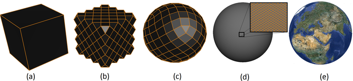
The digital Earth framework is a multiresolution 3D model used to visualize location-based data. In this paper, we introduce a new digital Earth framework using a cube as its underlying polyhedron. To create multiresolution, we introduce two types of 1-to-2 refinement. Having a smaller factor of refinement enables us to provide more resolutions and therefore a smoother transition among resolutions. We also suggest two indexing methods specifically designed for quadrilateral cells resulting from 1-to-2 refinement. We finally discuss the equal area spherical projection that we are using in this framework to model the Earth as a sphere partitioned to equal area cells.
Ali Mahdavi-Amiri
Alumni Postdoc and Research Associate
April 2015 - December 2016
Ali is a former Postdoctoral Scholar interested in geometric modelling, geospatial visualization, Digital Earth representations, and spatial data structures.