3d maquetter: Sketch-based 3d content modeling for digital earth
Abstract
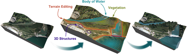
We present a sketch-based system for the creation and editing 3D content such as Digital Elevation Models, vegetation and bodies of water for Digital Earth representations. The proposed system employs a set of sketch-based tools to integrate commonly available data sources, such as orthophotos and Digital Elevation Models (DEM), to facilitate the rapid creation and integration of detailed geospatial content. Consequently, our system can be used to enhance the quality of Digital Earth data by enabling the straightforward creation of new 3D landscape elements.
Type
Publication
2015 International Conference on Cyberworlds (CW) (IEEE)