Efficient Calculation of Distance Transform on Discrete Global Grid Systems
Abstract
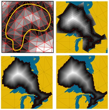
Geospatial data analysis often requires the computing of a distance transform for a given vector feature. For instance, in wildfire management, it is helpful to find the distance of all points in an area from the wildfire’s boundary. Computing a distance transform on traditional Geographic Information Systems (GIS) is usually adopted from image processing methods, albeit prone to distortion resulting from flat maps. Discrete Global Grid Systems (DGGS) are relatively new low-distortion globe-based GIS that discretize the Earth into highly regular cells using multiresolution grids. In this paper, we introduce an efficient distance transform algorithm for DGGS. Our novel algorithm heavily exploits the hierarchy of a DGGS and its mathematical properties and applies to many different DGGSs. We evaluate our method by comparing its speed and distortion with the distance transform methods used in traditional GIS and general 3D meshes. We demonstrate that our method is efficient and has minimal distortion.
Meysam Kazemi
Alumni M.Sc. Student
September 2019 - September 2023
Meysam is an MSc graduate with a strong interest in Digital Earth.