Physical visualization of geospatial datasets
Abstract
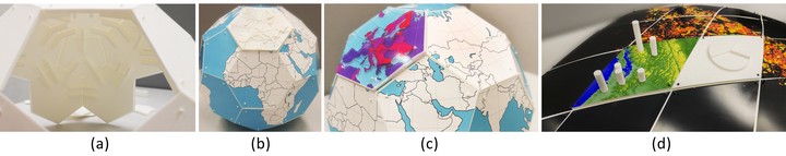
Geospatial datasets are too complex to easily visualize and understand on a computer screen. Combining digital fabrication with a discrete global grid system (DGGS) can produce physical models of the Earth for visualizing multiresolution geospatial datasets. This proposed approach includes a mechanism for attaching a set of 3D printed segments to produce a scalable model of the Earth. The authors have produced two models that support the attachment of different datasets both in 2D and 3D format.
Hessam Djavaherpour
Alumni Ph.D. Student
January 2016 - July 2021
Hessam was an architect and a PhD candidate in Computational Media Design (CMD). His research interests include digital fabrication, data physicalization and data spatialization, data-centric design approaches, responsive architecture, and dynamic structures. Hessam has an MSc in architecture from the Iran University of Science and Technology.